
1976 Map of New Home NE
USGS Topo · Published 1978About this map
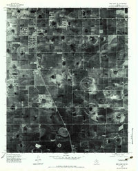
Agricultural patterns on the Texas South Plains are revealed in this 1976 orthophotoquad, which utilizes aerial imagery to document the rural landscape south of Lubbock. The orthophoto format provides a direct view of the circular irrigation patterns and rectangular field divisions that characterize this portion of the Llano Estacado. The small settlement of Woodrow sits near the western edge of the sheet, situated along a primary north-south roadway, while the community of Union is positioned further east. These labels identify the social and commercial hubs for the surrounding farming families. Unlike a traditional topographic map, this imagery preserves the actual ground texture of the era, showing the distinct playas—natural shallow depressions—that dot the landscape and serve as critical drainage points for the region's intensive cotton and grain operations.
Find a feature on this map
2 named features on this map. Tap any name to fly to it.
Don’t see what you’re looking for? This feature index may not catch every label — zoom into the map to look around manually.
Map Details
Editions of this 1976 New Home NE Map
2 editions found
Other maps of this area

1954 · Lubbock
USGS Topo · 1:250,000

1957 · Lubbock East
USGS Topo · 1:24,000

1957 · New Home
USGS Topo · 1:62,500

1957 · Lubbock West
USGS Topo · 1:24,000

1957 · Lubbock
USGS Topo · 1:62,500

1965 · Slaton
USGS Topo · 1:24,000

1965 · Buffalo Springs Lake
USGS Topo · 1:24,000

1965 · Wilson
USGS Topo · 1:24,000

1976 · New Home NW
USGS Topo · 1:24,000
1976 · New Home SE
USGS Topo · 1:24,000