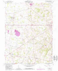
1960 Map of New Market
USGS Topo · Published 1987About this map
The Oldaker State Wildlife Area occupies the northwest portion of this Highland County landscape, where the headwaters of Dodson Creek and South Fork begin their descent through the agricultural hills. The eastern edge of the survey reaches into Hillsboro, the regional center for trade and transport, while smaller settlements like New Market, Fairview, and Shackleton serve as crossroads for the surrounding farming community. The terrain is defined by low rises such as Horner Hill and Pea Ridge, which separate the various branches of the North Fork White Oak Creek and the Rocky Fork. Genealogy researchers will find an exceptionally high density of small family and community burial grounds, including the three Fenner cemeteries, Old Dutch Cem, and Strange Cem, many located at the ends of rural lanes or near early congregations like South Liberty Ch. The Norfolk and Western rail line cuts across the southern townships, marking the era's primary industrial corridor.
Find a feature on this map
48 named features on this map. Tap any name to fly to it.
Don’t see what you’re looking for? This feature index may not catch every label — zoom into the map to look around manually.
Map Details
Editions of this 1960 New Market Map
3 editions found
Other maps of this area

1907 · Blanchester
USGS Topo · 1:62,500

1917 · Hillsboro
USGS Topo · 1:62,500

1917 · Sabina
USGS Topo · 1:62,500

1917 · Sardinia
USGS Topo · 1:62,500

1943 · Sabina
USGS Topo · 1:62,500

1944 · Hillsboro
USGS Topo · 1:62,500

1944 · Sardinia
USGS Topo · 1:62,500

1947 · Columbus
USGS Topo · 1:250,000
1960 · Lynchburg
USGS Topo · 1:24,000

1960 · Martinsville
USGS Topo · 1:24,000