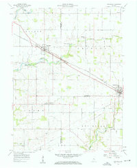
1957 Map of New Ross
USGS Topo · Published 1959About this map
New York Central rail lines anchor the agricultural landscape of this central Indiana region in the late 1950s, connecting the small grain and trade centers of New Ross and Jamestown. The terrain is defined by the winding paths of Big Raccoon Creek and the West Fork Walnut Creek, where the drainage patterns helped dictate the placement of early homesteads and community structures. Local family history is well-preserved through numerous rural burial grounds, including the Brown Cem, Porter Cem, and Hicks Cem, often situated near small country churches like Mt Zion Ch. This survey captures the rural infrastructure just as modern utility corridors began to bisect the townships of Walnut, Jackson, and Clark, evidenced by the prominent Pipeline routes cutting across the southeastern sections near the Boone and Hendricks County boundaries.
Find a feature on this map
28 named features on this map. Tap any name to fly to it.
Don’t see what you’re looking for? This feature index may not catch every label — zoom into the map to look around manually.
Map Details
Editions of this 1957 New Ross Map
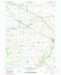
Other maps of this area

1953 · Lizton
USGS Topo · 1:24,000

1953 · Danville
USGS Topo · 1:24,000

1953 · Danville
USGS Topo · 1:250,000

1953 · Indianapolis
USGS Topo · 1:250,000

1955 · Danville
USGS Topo · 1:250,000

1956 · Danville
USGS Topo · 1:250,000

1956 · Indianapolis
USGS Topo · 1:250,000

1957 · Indianapolis
USGS Topo · 1:250,000

1957 · New Ross
USGS Topo · 1:24,000

1958 · Darlington
USGS Topo · 1:24,000