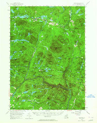
1954 Map of Newcomb
USGS Topo · Published 1964About this map
Newcomb serves as the central hub of this mid-century survey, situated between the expansive Rich Lake and Harris Lake. The map documents a landscape dominated by the high peaks and water systems of the Adirondack State Park, where the Hudson River and Goodnow River carve through complex topography. Notable for its recreation and conservation history, the sheet identifies specific enclaves like the Tahawus Club and the Northwoods Club Pond, alongside the prominent Lookout Tower atop Goodnow Mountain. Beyond the main settlement, the remote outposts of Aiden Lair and the Newcomb Cem provide vital reference points for local history. The presence of numerous named lakes, from the numbered Third Lake through Eighth Lake to secluded basins like Mink Pond, illustrates a late-frontier wilderness being managed for both resource protection and seasonal residency.
Find a feature on this map
152 named features on this map. Tap any name to fly to it.
Don’t see what you’re looking for? This feature index may not catch every label — zoom into the map to look around manually.
Map Details
Editions of this 1954 Newcomb Map
5 editions found

Other maps of this area

1895 · North Creek
USGS Topo · 1:62,500

1895 · Mt. Marcy
USGS Topo · 1:62,500

1897 · North Creek
USGS Topo · 1:62,500

1897 · Schroon Lake
USGS Topo · 1:62,500

1898 · Newcomb
USGS Topo · 1:62,500

1898 · Thirteenth Lake
USGS Topo · 1:62,500

1899 · Indian Lake
USGS Topo · 1:62,500

1901 · Newcomb
USGS Topo · 1:62,500

1902 · Mt. Marcy
USGS Topo · 1:62,500

1902 · Indian Lake
USGS Topo · 1:62,500