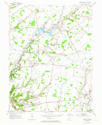
1953 Map of Newtonsville
USGS Topo · Published 1967About this map
Stonelick Lake State Reserve dominates the central landscape of this Clermont County survey, capturing the region just as the 1950s began. The map documents a predominantly agrarian interior Ohio, where small crossroad settlements like Newtonsville and Edenton serve as local hubs connected by a network of historic pikes and roads. Evidence of the early pioneer and family settlement patterns is found in numerous burial grounds, including Edenton Cem, Plainview Cem, and Hartman Cem. To the south, the terrain becomes more varied as it approaches the East Fork Little Miami River drainage, with several creeks like Moores Fork and Stonelick Creek carving through the township boundaries of Goshen, Wayne, and Jackson. The presence of both Stonelick Lake and the smaller Lake Monterey indicates the mid-century development of water resources and recreational spaces amidst the established farmsteads and rural townships.
Find a feature on this map
39 named features on this map. Tap any name to fly to it.
Don’t see what you’re looking for? This feature index may not catch every label — zoom into the map to look around manually.
Map Details
Editions of this 1953 Newtonsville Map
2 editions found

Other maps of this area

1907 · Blanchester
USGS Topo · 1:62,500

1914 · Batavia
USGS Topo · 1:48,000

1914 · Morrow
USGS Topo · 1:62,500

1916 · Batavia
USGS Topo · 1:62,500

1916 · Morrow
USGS Topo · 1:62,500

1917 · Sardinia
USGS Topo · 1:62,500

1944 · Sardinia
USGS Topo · 1:62,500

1947 · Columbus
USGS Topo · 1:250,000

1953 · Goshen
USGS Topo · 1:24,000
1953 · Batavia
USGS Topo · 1:24,000