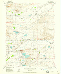
1950 Map of Niwot
USGS Topo · Published 1959About this map
Niwot stands as a central agricultural hub north of the developing city of Boulder at the turn of the 1950s. The landscape is defined by an intricate network of irrigation canals like Farmers Ditch and Liggett Ditch, which transformed the arid high plains into a productive farming district. The Colorado and Southern railroad tracks bisect the region, connecting smaller junctions and settlements. To the south, Valmont appears as a center of industry and utility, anchored by the power plant and the prominent volcanic landmark of Valmont Butte.
Find a feature on this map
52 named features on this map. Tap any name to fly to it.
Don’t see what you’re looking for? This feature index may not catch every label — zoom into the map to look around manually.
Map Details
Editions of this 1950 Niwot Map
4 editions found

Other maps of this area

1899 · West Denver
USGS Topo · 1:125,000

1902 · Boulder
USGS Topo · 1:62,500

1904 · Niwot
USGS Topo · 1:62,500

1904 · Boulder
USGS Topo · 1:62,500

1906 · Blackhawk
USGS Topo · 1:62,500

1940 · Lafayette
USGS Topo · 1:31,680

1942 · Eldorado Springs
USGS Topo · 1:24,000

1942 · Louisville
USGS Topo · 1:31,680

1944 · Lafayette
USGS Topo · 1:31,680

1944 · Eldorado Springs
USGS Topo · 1:31,680