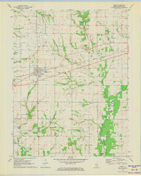
1971 Map of Noble
USGS Topo · Published 1973About this map
The town of Noble serves as the focal point of this early 1970s landscape, situated along the Baltimore and Ohio railroad line. The surrounding terrain in Richland County is a mix of agricultural fields and active energy extraction, notably the Noble Oil Field and the Schnell East Oil Field. These industrial zones are interspersed with established rural communities like Pureton, Gallagher, and Schnell, each connected by a network of section roads.
Find a feature on this map
35 named features on this map. Tap any name to fly to it.
Don’t see what you’re looking for? This feature index may not catch every label — zoom into the map to look around manually.
Map Details
Editions of this 1971 Noble Map
2 editions found
Other maps of this area

1941 · Newton
USGS Topo · 1:62,500

1943 · Newton
USGS Topo · 1:62,500

1948 · Flora
USGS Topo · 1:62,500

1949 · Olney
USGS Topo · 1:62,500

1949 · Flora
USGS Topo · 1:62,500

1953 · Sailor Springs
USGS Topo · 1:62,500

1958 · Belleville
USGS Topo · 1:250,000

1962 · Belleville
USGS Topo · 1:250,000

1970 · Clay City
USGS Topo · 1:24,000

1970 · Enterprise
USGS Topo · 1:24,000