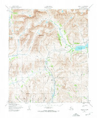
1950 Map of Nome D-1
USGS Topo · Published 1974About this map
The high peaks of the Kiglua K Mountains, including Mount Osborn and Tigaraha Mountain, dominate this interior region of the Seward Peninsula. The landscape is defined by the resource extraction infrastructure necessary for Arctic mining, most notably the Miocene Ditch and various other drainage systems like Ditch that contour around the steep terrain to move water for hydraulic operations. Settlement is sparse and largely functional, represented by Jensens Camp and a Roadhouse located near a Landing Strip at the eastern edge of the survey. Significant waterways such as the Sinuk River, Nome River, and Cobblestone River carve deep valleys through the uplands, while the presence of (Sinrock) suggests an earlier or seasonal habitation site. The network of pack trails and abandoned routes, including a primary Trail winding through the south, illustrates the difficult transit through Mosquito Pass and across the many gulches like Hill Gulch and Jack Gulch.
Find a feature on this map
69 named features on this map. Tap any name to fly to it.
Don’t see what you’re looking for? This feature index may not catch every label — zoom into the map to look around manually.
Map Details
Editions of this 1950 Nome D-1 Map
3 editions found
Other maps of this area

1950 · Bendeleben A-6
USGS Topo · 1:63,360

1950 · Nome D-2
USGS Topo · 1:63,360

1950 · Nome
USGS Topo · 1:250,000

1950 · Solomon C-6
USGS Topo · 1:63,360

1950 · Teller
USGS Topo · 1:250,000

1950 · Bendeleben
USGS Topo · 1:250,000

1950 · Teller A-2
USGS Topo · 1:63,360

1950 · Solomon
USGS Topo · 1:250,000

1950 · Solomon D-6
USGS Topo · 1:63,360

1950 · Nome D-1
USGS Topo · 1:63,360