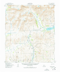
1950 Map of Nome D-1
USGS Topo · Published 1977About this map
The Kigluaiak Mountains dominate this northern landscape, rising to peaks such as Mount Osborn and Tigaraha Mountain. The high-altitude terrain is defined by glacial features and alpine waters, most notably the deep basin of Salmon Lake and the smaller Crater Lake to the north. Drainage systems like the Nome River and Grand Central River carve through the mountain passes, reflecting the hydrological patterns of the Seward Peninsula before significant modern infrastructure.
Find a feature on this map
78 named features on this map. Tap any name to fly to it.
Don’t see what you’re looking for? This feature index may not catch every label — zoom into the map to look around manually.
Map Details
Editions of this 1950 Nome D-1 Map
3 editions found
Other maps of this area

1950 · Bendeleben A-6
USGS Topo · 1:63,360

1950 · Nome D-2
USGS Topo · 1:63,360

1950 · Nome
USGS Topo · 1:250,000

1950 · Solomon C-6
USGS Topo · 1:63,360

1950 · Teller
USGS Topo · 1:250,000

1950 · Bendeleben
USGS Topo · 1:250,000

1950 · Teller A-2
USGS Topo · 1:63,360

1950 · Solomon
USGS Topo · 1:250,000

1950 · Solomon D-6
USGS Topo · 1:63,360

1950 · Nome D-1
USGS Topo · 1:63,360