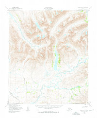
1950 Map of Nome D-2
USGS Topo · Published 1976About this map
The Kigluaiak Mountains dominate this 1950s interior landscape of the Seward Peninsula, revealing a complex drainage system defined by the Sinuk River and Stewart River. At the heart of the mountains, Glacial Lake sits as a significant water body, fed by the Grand Central River and Glacier Creek. The presence of a lone Cabin along the riverbank suggests the sparse human footprint characteristic of this subarctic wilderness during the mid-twentieth century. Transportation across this remote terrain is limited to the Nome Teller Highway, which skirts the southwestern edge of the quadrangle near Livingston Creek. The map documents a landscape of braided river valleys and high-elevation basins, including the headwaters of the Feather River and Cobblestone River, providing a detailed record of the region's topography before more modern developments reached the Alaskan interior.
Find a feature on this map
22 named features on this map. Tap any name to fly to it.
Don’t see what you’re looking for? This feature index may not catch every label — zoom into the map to look around manually.
Map Details
Editions of this 1950 Nome D-2 Map
3 editions found
Other maps of this area

1950 · Nome D-2
USGS Topo · 1:63,360

1950 · Nome
USGS Topo · 1:250,000

1950 · Teller
USGS Topo · 1:250,000

1950 · Teller A-2
USGS Topo · 1:63,360
1950 · Nome C-3
USGS Topo · 1:63,360

1950 · Nome D-1
USGS Topo · 1:63,360

1950 · Teller A-1
USGS Topo · 1:63,360

1950 · Nome D-3
USGS Topo · 1:63,360

1950 · Nome C-2
USGS Topo · 1:63,360

1950 · Nome C-1
USGS Topo · 1:63,360