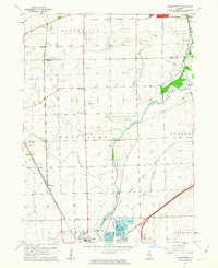
1962 Map of Normantown
USGS Topo · Published 1963About this map
Elgin Joliet And Eastern railroad tracks cut a sharp diagonal through this corner of the Illinois prairie, linking the small agricultural settlements of Frontenac and Normantown. The landscape in the early 1960s reveals a transition from traditional farming to modern infrastructure, evidenced by the presence of three small aviation facilities: Aero Airport, Matter Airport, and Plainfield Airport. Rural community life is anchored by family-centered landmarks such as Vermont Cem, Wheatland Cem, and Wheatland Sch. In the southeast, industrial activity is concentrated near the Du Page River around large Gravel Pits and the specialized Industrial Railroad. This survey captures the region just as the suburban influence of Naperville and Plainfield began to reach across the township boundaries of Wheatland and Lisle.
Find a feature on this map
30 named features on this map. Tap any name to fly to it.
Don’t see what you’re looking for? This feature index may not catch every label — zoom into the map to look around manually.
Map Details
Editions of this 1962 Normantown Map
3 editions found
Other maps of this area

1892 · Joliet
USGS Topo · 1:62,500

1908 · Wheaton
USGS Topo · 1:62,500

1923 · Joliet
USGS Topo · 1:62,500

1925 · Yorkville
USGS Topo · 1:62,500

1932 · Geneva
USGS Topo · 1:62,500

1948 · Wheaton
USGS Topo · 1:62,500

1948 · Geneva
USGS Topo · 1:62,500

1950 · Aurora North
USGS Topo · 1:24,000

1953 · Naperville
USGS Topo · 1:24,000

1953 · Yorkville SE
USGS Topo · 1:24,000