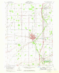
1960 Map of North Baltimore
USGS Topo · Published 1971About this map
North Baltimore sits at the intersection of a complex rail-and-road network, where the New York Central railroad and major highways cut through the flat agricultural lands of Wood and Hancock Counties. The landscape is a study in early-1960s industrial and agricultural development, characterized by numerous Oil Wells and a prominent Tank Farm near Cygnet. Cultural landmarks for genealogists are plentiful, including Fayler Cem, Maplewood Cem, and the United Brethren Ch. To the south, the Van Buren Lake State Reserve provides a clear boundary for the town of Van Buren, while the northern reaches include smaller clusters like Hammansburg and the quarry-rich area near Needles Road. The presence of several Quarries and water management features like the Waterworks and Sewage Disposal plant reflects the infrastructure required to support these growing mid-century Ohio communities.
Find a feature on this map
44 named features on this map. Tap any name to fly to it.
Don’t see what you’re looking for? This feature index may not catch every label — zoom into the map to look around manually.
Map Details
Editions of this 1960 North Baltimore Map
4 editions found
Other maps of this area

1901 · Bowling Green
USGS Topo · 1:62,500

1903 · Bowling Green
USGS Topo · 1:62,500

1903 · Findlay
USGS Topo · 1:62,500

1909 · Mc Clure
USGS Topo · 1:62,500

1956 · Toledo
USGS Topo · 1:250,000

1958 · Jerry City
USGS Topo · 1:24,000

1958 · Bowling Green South
USGS Topo · 1:24,000

1960 · Bloomdale
USGS Topo · 1:24,000

1960 · North Baltimore
USGS Topo · 1:24,000
1960 · Weston
USGS Topo · 1:24,000
Featured Places
- North Baltimore, OH
- Cygnet, OH
- Van Buren, OH
- North Baltimore, OH
- Eagle Landing Mobile Home Park, North Baltimore