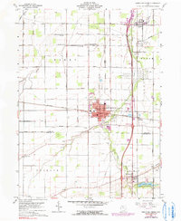
1960 Map of North Baltimore
USGS Topo · Published 1991About this map
North Baltimore serves as the central hub of this 1960 landscape, where the Baltimore and Ohio rail line intersects with a grid of rural roads including Hammansburg Road and Belmore Road. The area shows a transition from agricultural fields to heavy infrastructure, notably around Cygnet where a large Tank Farm and numerous pipelines indicate the region's mid-century role in energy transport. To the south, the Van Buren Lake State Reserve provides a distinct recreational contrast to the industrial quarries and gravel pits scattered near the village centers.
Find a feature on this map
44 named features on this map. Tap any name to fly to it.
Don’t see what you’re looking for? This feature index may not catch every label — zoom into the map to look around manually.
Map Details
Editions of this 1960 North Baltimore Map
4 editions found
Other maps of this area

1901 · Bowling Green
USGS Topo · 1:62,500

1903 · Bowling Green
USGS Topo · 1:62,500

1903 · Findlay
USGS Topo · 1:62,500

1909 · Mc Clure
USGS Topo · 1:62,500

1956 · Toledo
USGS Topo · 1:250,000

1958 · Jerry City
USGS Topo · 1:24,000

1958 · Bowling Green South
USGS Topo · 1:24,000

1960 · Bloomdale
USGS Topo · 1:24,000

1960 · North Baltimore
USGS Topo · 1:24,000
1960 · Weston
USGS Topo · 1:24,000
Featured Places
- North Baltimore, OH
- Cygnet, OH
- Van Buren, OH
- North Baltimore, OH
- Eagle Landing Mobile Home Park, North Baltimore