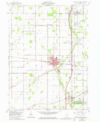
1960 Map of North Baltimore
USGS Topo · Published 1973About this map
North Baltimore is a central junction in this 1960s study, showcasing a landscape defined by the intersection of the Baltimore and Ohio and Central Penn railroads. The area south of the Wood Co Hancock Co line features the recreational development of Van Buren Lake State Reserve and the village of Van Buren. Rural life is marked by numerous family-named sites and community markers, including Fowler Cem, Bechel Cem, and the United Brethren Ch. Industrial activity is evident through a series of Quarry sites and concentrated Tank Farm facilities near Cygnet, illustrating the region's mid-century role in transportation and resource storage. Waterways like Rader Creek and Rocky Ford drain the flatlands of Bloom and Henry townships, where small schools like Township Sch once served the dispersed farming population.
Find a feature on this map
41 named features on this map. Tap any name to fly to it.
Don’t see what you’re looking for? This feature index may not catch every label — zoom into the map to look around manually.
Map Details
Editions of this 1960 North Baltimore Map
4 editions found
Other maps of this area

1901 · Bowling Green
USGS Topo · 1:62,500

1903 · Bowling Green
USGS Topo · 1:62,500

1903 · Findlay
USGS Topo · 1:62,500

1909 · Mc Clure
USGS Topo · 1:62,500

1956 · Toledo
USGS Topo · 1:250,000

1958 · Jerry City
USGS Topo · 1:24,000

1958 · Bowling Green South
USGS Topo · 1:24,000

1960 · Bloomdale
USGS Topo · 1:24,000

1960 · North Baltimore
USGS Topo · 1:24,000
1960 · Weston
USGS Topo · 1:24,000
Featured Places
- North Baltimore, OH
- Cygnet, OH
- Van Buren, OH
- North Baltimore, OH
- Eagle Landing Mobile Home Park, North Baltimore