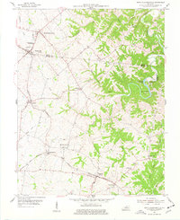
1954 Map of North Pleasureville
USGS Topo · Published 1977About this map
The rolling borderlands of Henry and Shelby Counties are defined here by a series of rural rail stops and agricultural hamlets during the mid-1950s. The Louisville and Nashville railroad serves as the primary spine for the region, connecting Pleasureville and North Pleasureville in the north to Cropper, Christianburg, and the community of Bagdad further south. This corridor highlights the importance of the rail-and-road network to Kentucky's mid-century rural economy, where the Consolidated High Sch and various Cem markers indicate the center of local social life.
Find a feature on this map
37 named features on this map. Tap any name to fly to it.
Don’t see what you’re looking for? This feature index may not catch every label — zoom into the map to look around manually.
Map Details
Editions of this 1954 North Pleasureville Map
3 editions found
Other maps of this area

1906 · Lockport
USGS Topo · 1:48,000

1908 · Lockport
USGS Topo · 1:62,500

1922 · Frankfort
USGS Topo · 1:48,000

1923 · Waddy
USGS Topo · 1:48,000

1924 · Frankfort
USGS Topo · 1:62,500

1925 · Mount Eden
USGS Topo · 1:48,000

1927 · Mount Eden
USGS Topo · 1:62,500

1928 · New Castle
USGS Topo · 1:48,000

1932 · New Castle
USGS Topo · 1:62,500

1953 · Gratz
USGS Topo · 1:24,000