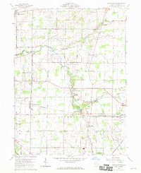
1960 Map of North Robinson
USGS Topo · Published 1970About this map
The Sandusky River winds through the northern reaches of this Crawford County landscape, where the rural character of the 1960s is defined by small crossroads settlements and family farms. The Pennsylvania railroad corridor serves as a primary axis for the region, passing directly through North Robinson and toward the industrial edges of Crestline. This survey captures the area just as Lake Galion and its surrounding parkland provided a central recreational focus for local residents.
Find a feature on this map
44 named features on this map. Tap any name to fly to it.
Don’t see what you’re looking for? This feature index may not catch every label — zoom into the map to look around manually.
Map Details
Editions of this 1960 North Robinson Map
4 editions found

Other maps of this area

1913 · Mount Gilead
USGS Topo · 1:62,500

1915 · Bucyrus
USGS Topo · 1:62,500

1915 · Crestline
USGS Topo · 1:62,500

1915 · Shauck
USGS Topo · 1:62,500

1916 · Mount Gilead
USGS Topo · 1:62,500

1943 · Shauck
USGS Topo · 1:62,500

1943 · Bucyrus
USGS Topo · 1:62,500

1943 · Crestline
USGS Topo · 1:62,500

1943 · Mount Gilead
USGS Topo · 1:62,500

1950 · Marion
USGS Topo · 1:250,000