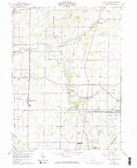
1960 Map of North Robinson
USGS Topo · Published 1974About this map
The Sandusky River and its tributary, Loss Creek, define the central drainage of this Crawford County landscape during the early 1960s. The region is characterized by a dense grid of rural roads and small agricultural settlements, with North Robinson and Leesville serving as primary local hubs. The southern portion of the map is intersected by the Penn Central railroad, which runs parallel to Crestline Road toward the town of Crestline. Local social and religious history is preserved through numerous rural landmarks, including Immanuel Ch, Sandusky Cem, and Windfall Cem. Near the center of the sheet, the presence of the Drive-in Theater and a nearby Golf Course reflect mid-century recreational patterns. North of Lake Galion, several Gravel Pit operations suggest the local extraction industries that supported regional infrastructure development.
Find a feature on this map
56 named features on this map. Tap any name to fly to it.
Don’t see what you’re looking for? This feature index may not catch every label — zoom into the map to look around manually.
Map Details
Editions of this 1960 North Robinson Map
4 editions found

Other maps of this area

1913 · Mount Gilead
USGS Topo · 1:62,500

1915 · Bucyrus
USGS Topo · 1:62,500

1915 · Crestline
USGS Topo · 1:62,500

1915 · Shauck
USGS Topo · 1:62,500

1916 · Mount Gilead
USGS Topo · 1:62,500

1943 · Shauck
USGS Topo · 1:62,500

1943 · Bucyrus
USGS Topo · 1:62,500

1943 · Crestline
USGS Topo · 1:62,500

1943 · Mount Gilead
USGS Topo · 1:62,500

1950 · Marion
USGS Topo · 1:250,000