
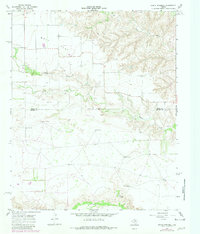
1967 Map of North Windmill
USGS Topo · Published 1969About this map
Wolf Flat dominates the northwestern portion of this 1967 survey, where the high plains of the Panhandle begin their descent into the broken canyonlands of the Wind River and Turkey Creek. This landscape is defined by its water infrastructure, marked by a network of family-named pumping stations like Reese Windmill, Groves Windmill, and Barton Windmill. These features indicate the essential nature of groundwater for cattle ranching in a region where surface water is intermittent.
Find a feature on this map
15 named features on this map. Tap any name to fly to it.
Don’t see what you’re looking for? This feature index may not catch every label — zoom into the map to look around manually.
Map Details
Editions of this 1967 North Windmill Map
2 editions found
Other maps of this area

1954 · Plainview
USGS Topo · 1:250,000

1958 · Plainview
USGS Topo · 1:250,000

1967 · Cottonwood Camp
USGS Topo · 1:24,000

1967 · Tampico Siding
USGS Topo · 1:24,000

1967 · Hornica Creek
USGS Topo · 1:24,000

1967 · Turtle Hole Camp
USGS Topo · 1:24,000

1967 · Flomot
USGS Topo · 1:24,000

1967 · Turkey
USGS Topo · 1:24,000

1967 · Blue Tank Canyon
USGS Topo · 1:24,000
1967 · Folley
USGS Topo · 1:24,000