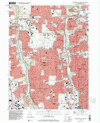
1995 Map of Northwest Columbus
USGS Topo · Published 1999About this map
Columbus and its northern suburbs are defined by the parallel paths of the Scioto River and Olentangy River during this mid-1990s period of suburban density. The map illustrates a complex landscape of institutional and recreational land use, featuring the sprawling campus of Ohio State University at the southern edge and the specialized facilities of the State School for the Deaf and the State School for the Blind to the north. Transportation and public works infrastructure is prominent, from the Ohio State University Airport and RR Museum to the expansive Griggs Reservoir along the western boundary. The survey also captures the distinct boundaries of established communities like Worthington, Upper Arlington, and the village of Riverlea, alongside historical landmarks such as the Union Cemetery and the Ohio National Guard Armory.
Find a feature on this map
104 named features on this map. Tap any name to fly to it.
Don’t see what you’re looking for? This feature index may not catch every label — zoom into the map to look around manually.
Map Details
Editions of this 1995 Northwest Columbus Map
2 editions found
Other maps of this area

1901 · Dublin
USGS Topo · 1:62,500

1902 · Westerville
USGS Topo · 1:62,500

1903 · Dublin
USGS Topo · 1:62,500

1904 · Westerville
USGS Topo · 1:62,500

1923 · West Columbus
USGS Topo · 1:62,500

1925 · East Columbus
USGS Topo · 1:62,500

1925 · West Columbus
USGS Topo · 1:62,500

1943 · East Columbus
USGS Topo · 1:62,500

1947 · Columbus
USGS Topo · 1:250,000

1950 · Marion
USGS Topo · 1:250,000