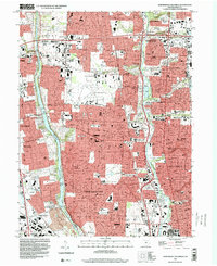
1995 Map of Northwest Columbus
USGS Topo · Published 2000About this map
The Scioto River and Olentangy River define the North Columbus corridor during a period of significant suburban expansion in Franklin County. This map highlights the complex division of land between the United States Military District and the Virginia Military District, with the river acting as the historical boundary line. The landscape is a dense mix of residential growth and institutional landmarks, including the extensive grounds of the Ohio State University Airport and the specialized campuses of the State School for the Deaf and the State School for the Blind. To the west, the Griggs Reservoir provides a wide blue break in the developing grid of Upper Arlington and Hilliard. Local history and genealogy interest is anchored by traditional sites like Union Cemetery, Kempton Cem, and several parochial schools such as St Agatha Sch and St Brendan Sch. The presence of the Ohio National Guard Armory and the Sawmill State Wildlife Education Area reflects the continued diverse use of space as the city edges northward toward Dublin and Worthington.
Find a feature on this map
67 named features on this map. Tap any name to fly to it.
Don’t see what you’re looking for? This feature index may not catch every label — zoom into the map to look around manually.
Map Details
Editions of this 1995 Northwest Columbus Map
2 editions found
Other maps of this area

1901 · Dublin
USGS Topo · 1:62,500

1902 · Westerville
USGS Topo · 1:62,500

1903 · Dublin
USGS Topo · 1:62,500

1904 · Westerville
USGS Topo · 1:62,500

1923 · West Columbus
USGS Topo · 1:62,500

1925 · East Columbus
USGS Topo · 1:62,500

1925 · West Columbus
USGS Topo · 1:62,500

1943 · East Columbus
USGS Topo · 1:62,500

1947 · Columbus
USGS Topo · 1:250,000

1950 · Marion
USGS Topo · 1:250,000