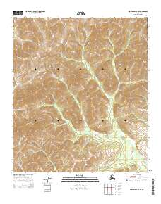
2014 Map of Norton Bay B-1 SE
USGS Topo · Published 2014About this map
The Kaltag Mountains and Nulato Hills dominate this portion of the Alaskan interior, representing a landscape defined by significant elevation changes and drainages. The Kaltag River winds through the central and eastern sections, carving a path through the high ground, while the Unatakleet River appears in the western reaches. This 2014 survey illustrates the complex topography of the Yukon-Koyukuk region, where the steep contour intervals highlight the natural corridors formed by these major watercourses. The map provides a detailed view of the remote terrain between the Yukon River and Norton Sound, documenting the uninhabited wilderness and the natural hydrology that has dictated travel routes through these mountains for generations.
Find a feature on this map
8 named features on this map. Tap any name to fly to it.
Don’t see what you’re looking for? This feature index may not catch every label — zoom into the map to look around manually.
Map Details
Editions of this 2014 Norton Bay B-1 SE Map
This is the sole edition of this map. No revisions or reprints were ever made.
Other maps of this area

1945 · Nulato
USGS Topo · 1:250,000

1948 · Norton Bay
USGS Topo · 1:250,000

1951 · Nulato
USGS Topo · 1:250,000

1951 · Norton Bay
USGS Topo · 1:250,000

1952 · Nulato B-6
USGS Topo · 1:63,360

1952 · Norton Bay B-1
USGS Topo · 1:63,360

1952 · Nulato
USGS Topo · 1:250,000

1952 · Nulato A-6
USGS Topo · 1:63,360
1954 · Norton Bay A-1
USGS Topo · 1:63,360

1955 · Norton Bay
USGS Topo · 1:250,000