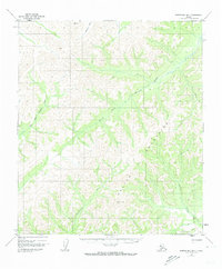
1952 Map of Norton Bay B-1
USGS Topo · Published 1973About this map
The Kaltag Portage Sled Trail cuts across the southeast corner of this subarctic landscape, marking a vital historic corridor between the Yukon River and Norton Sound. This 1952 topographic study, revised in 1973, reveals a rugged interior dominated by the northern reaches of the Kaiyuh Mountains. The drainage patterns here are complex, defined by the headwaters of several major Alaskian waterways. The Unalakleet River and its South Fork dominate the western half, while the Kaltag River and Nulato River drain the eastern slopes. The lack of established settlements emphasizes the remote character of the region during the mid-20th century, where travel relied on seasonal routes like the sled trail and the natural highways of the river systems.
Find a feature on this map
7 named features on this map. Tap any name to fly to it.
Don’t see what you’re looking for? This feature index may not catch every label — zoom into the map to look around manually.
Map Details
Editions of this 1952 Norton Bay B-1 Map
2 editions found
Other maps of this area

1945 · Nulato
USGS Topo · 1:250,000

1948 · Norton Bay
USGS Topo · 1:250,000

1951 · Nulato
USGS Topo · 1:250,000

1951 · Norton Bay
USGS Topo · 1:250,000

1952 · Nulato B-6
USGS Topo · 1:63,360

1952 · Norton Bay B-1
USGS Topo · 1:63,360

1952 · Nulato C-6
USGS Topo · 1:63,360

1952 · Nulato
USGS Topo · 1:250,000

1952 · Nulato A-6
USGS Topo · 1:63,360
1952 · Norton Bay C-1
USGS Topo · 1:63,360