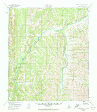
1950 Map of Norton Bay C-3
USGS Topo · Published 1971About this map
Shaktoolik River meanders through this interior Alaskan terrain, forming a complex watershed alongside its major tributaries. Photogrammetric methods from 1950 aerial surveys reveal a landscape defined by sharp drainage divides and narrow valley floors, primarily documented for civil use by the Geological Survey. Human presence is sparse, marked only by a solitary Cabin in the southwestern corner, reflecting the remote nature of the region near Norton Bay. The intricate paths of Kingmetolik Creek and Christmas Creek illustrate the natural drainage patterns of this unsurveyed territory before extensive modern development. These maps are particularly useful for understanding the historic waterway routes used for navigation and subsistence in the Seward Peninsula region.
Find a feature on this map
4 named features on this map. Tap any name to fly to it.
Don’t see what you’re looking for? This feature index may not catch every label — zoom into the map to look around manually.
Map Details
Editions of this 1950 Norton Bay C-3 Map
3 editions found
Other maps of this area

1948 · Norton Bay
USGS Topo · 1:250,000

1950 · Norton Bay B-4
USGS Topo · 1:63,360

1950 · Norton Bay D-4
USGS Topo · 1:63,360

1950 · Norton Bay B-3
USGS Topo · 1:63,360

1950 · Norton Bay C-3
USGS Topo · 1:63,360

1950 · Norton Bay D-3
USGS Topo · 1:63,360

1950 · Norton Bay C-4
USGS Topo · 1:63,360

1951 · Norton Bay
USGS Topo · 1:250,000
1953 · Norton Bay B-2
USGS Topo · 1:63,360

1953 · Norton Bay C-2
USGS Topo · 1:63,360