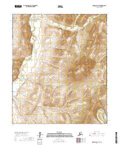
2017 Map of Norton Bay C-4 SE
USGS Topo · Published 2017About this map
The Ungalik River meanders through this section of the Nulato Hills, providing a primary hydrological corridor in a landscape defined by dramatic elevation changes. As recorded by the U.S. Geological Survey in 2017, the terrain is anchored by the prominent Christmas Mtn in the east, which serves as a significant landmark for the surrounding watershed. Numerous drainages, including Christmas Cr, Willow Cr, and Diamond Cr, carve through the hills towards the larger river systems. In the southeast corner, the headwaters of the Shaktoolik River begin their course, illustrating the complex drainage patterns of the Nome Census Area. This map captures a remote subarctic environment where the natural topography dictated movement and land use long before formal township and range lines were established.
Find a feature on this map
11 named features on this map. Tap any name to fly to it.
Don’t see what you’re looking for? This feature index may not catch every label — zoom into the map to look around manually.
Map Details
Editions of this 2017 Norton Bay C-4 SE Map
This is the sole edition of this map. No revisions or reprints were ever made.
Other maps of this area

1948 · Norton Bay
USGS Topo · 1:250,000

1950 · Norton Bay B-4
USGS Topo · 1:63,360

1950 · Norton Bay B-3
USGS Topo · 1:63,360

1950 · Norton Bay C-3
USGS Topo · 1:63,360

1950 · Norton Bay C-4
USGS Topo · 1:63,360

1951 · Norton Bay
USGS Topo · 1:250,000

1955 · Norton Bay
USGS Topo · 1:250,000
2014 · Norton Bay C-4 NW
USGS Topo · 1:25,000
2014 · Norton Bay C-4 SW
USGS Topo · 1:25,000
2014 · Norton Bay C-4 NE
USGS Topo · 1:25,000