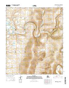
2014 Map of Norton Bay D-4 SE
USGS Topo · Published 2014About this map
The Inglutalik River meanders through this landscape, defining the local drainage patterns alongside the Ungalik River. In this part of the Norton Bay region, the terrain is marked by a series of overland transportation corridors that follow the natural topography. The Koyuk-Inglutalik River Road and the Inglutalik River Road provide critical access through the river valley, while the Tipuktuiliuraq Route traverses the higher ground to the north. These tracks represent the essential infrastructure of the area, connecting remote points across the varied elevations. The map provides a clear look at the public land survey system grid, showing the intersection of several townships including t7s r10w and t8s r9w, which helps in identifying specific land parcels and historical claims in the Alaskan interior.
Find a feature on this map
9 named features on this map. Tap any name to fly to it.
Don’t see what you’re looking for? This feature index may not catch every label — zoom into the map to look around manually.
Map Details
Editions of this 2014 Norton Bay D-4 SE Map
This is the sole edition of this map. No revisions or reprints were ever made.
Other maps of this area

1948 · Norton Bay
USGS Topo · 1:250,000

1950 · Norton Bay D-4
USGS Topo · 1:63,360

1950 · Norton Bay C-3
USGS Topo · 1:63,360

1950 · Norton Bay D-3
USGS Topo · 1:63,360

1950 · Norton Bay C-4
USGS Topo · 1:63,360

1951 · Norton Bay
USGS Topo · 1:250,000

1955 · Norton Bay
USGS Topo · 1:250,000
2014 · Norton Bay C-4 NW
USGS Topo · 1:25,000
2014 · Norton Bay D-4 SW
USGS Topo · 1:25,000
2014 · Norton Bay D-4 NW
USGS Topo · 1:25,000