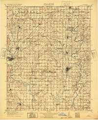
1914 Map of Nowata
USGS Topo · Published 1932About this map
Bartlesville and Nowata anchor this northeastern Oklahoma landscape just before the First World War, serving as vital hubs for the region's expanding rail and agricultural network. The map reveals a densely settled rural society defined by its local institutions, with dozens of named schoolhouses such as Cotton Valley School, Dogtown School, and Cherokee Central School dotting the countryside. Transit is dominated by the Missouri Kansas and Texas and the Atchison Topeka and Santa Fe railroads, which linked the small prairie towns of Lenapah, Delaware, and Watova to larger markets. Along the Caney River and its tributaries like Hogshooter Creek, the terrain transitions into complex drainage patterns, where small post offices like Howden Elliott PO and Adair Woodrow PO once served as essential community nodes before the advent of more centralized postal services.
Find a feature on this map
124 named features on this map. Tap any name to fly to it.
Don’t see what you’re looking for? This feature index may not catch every label — zoom into the map to look around manually.
Map Details
Editions of this 1914 Nowata Map
5 editions found

Other maps of this area

1885 · Sedan
USGS Topo · 1:125,000

1886 · Independence
USGS Topo · 1:125,000

1886 · Parsons
USGS Topo · 1:125,000

1889 · Sedan
USGS Topo · 1:125,000

1893 · Parsons
USGS Topo · 1:125,000

1894 · Independence
USGS Topo · 1:125,000

1896 · Pryor
USGS Topo · 1:125,000

1901 · Claremore
USGS Topo · 1:125,000

1901 · Nowata
USGS Topo · 1:125,000

1901 · Vinita
USGS Topo · 1:125,000