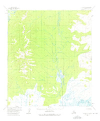
1952 Map of Nulato A-5
USGS Topo · Published 1975About this map
The Kateel River Range dominates the western landscape of this interior Alaskan territory, where the terrain descends into a vast network of watercourses and wetlands. Mapped primarily from 1952 aerial photography, the sheet documents a wilderness dominated by the meandering Kateel River and the complex drainage of the Mud River and Little Mud River. The absence of roads or permanent settlements in this 1950s survey reflects the remote nature of the region, where surveyors relied on benchmarks like VABM Katel 1550 to navigate the high ground. Interpretation of the landscape reveals a heavy reliance on natural hydrology, with Yukon Creek and Magitchlie Creek carving through the low-lying basins. This map captures the area in its raw, undeveloped state before modern infrastructure reached this portion of the Alaskan interior.
Find a feature on this map
7 named features on this map. Tap any name to fly to it.
Don’t see what you’re looking for? This feature index may not catch every label — zoom into the map to look around manually.
Map Details
Editions of this 1952 Nulato A-5 Map
2 editions found
Other maps of this area

1945 · Nulato
USGS Topo · 1:250,000

1951 · Ophir
USGS Topo · 1:250,000

1951 · Nulato
USGS Topo · 1:250,000

1952 · Nulato A-5
USGS Topo · 1:63,360

1952 · Nulato B-6
USGS Topo · 1:63,360

1952 · Nulato A-4
USGS Topo · 1:63,360

1952 · Nulato B-5
USGS Topo · 1:63,360

1952 · Nulato B-4
USGS Topo · 1:63,360

1952 · Nulato
USGS Topo · 1:250,000

1952 · Nulato A-6
USGS Topo · 1:63,360