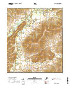
2019 Map of Nulato B-1 SW
USGS Topo · Published 2019About this map
Yuki River meanders across this interior Alaskan landscape, shaping a complex network of oxbows and wetlands in the north before giving way to increasingly steep terrain. The hydrology is dominated by the East Fork Yuki River, which cuts through the southwestern corner, reflecting a wilderness region defined by its drainage patterns rather than human settlement. The 2019 survey shows a landscape largely untouched by permanent infrastructure, marked primarily by the Public Land Survey System grids of t13s r12e, t13s r13e, t14s r12e, and t14s r13e. The tight contour intervals in the southeastern quadrant illustrate the significant elevation changes as the land rises away from the river valleys.
Find a feature on this map
6 named features on this map. Tap any name to fly to it.
Don’t see what you’re looking for? This feature index may not catch every label — zoom into the map to look around manually.
Map Details
Editions of this 2019 Nulato B-1 SW Map
This is the sole edition of this map. No revisions or reprints were ever made.
Other maps of this area

1945 · Nulato
USGS Topo · 1:250,000

1951 · Nulato
USGS Topo · 1:250,000

1952 · Nulato B-2
USGS Topo · 1:63,360

1952 · Nulato B-1
USGS Topo · 1:63,360

1952 · Nulato A-2
USGS Topo · 1:63,360
1952 · Nulato A-1
USGS Topo · 1:63,360

1952 · Nulato
USGS Topo · 1:250,000
1953 · Nulato B-1
USGS Topo · 1:63,360

1964 · Nulato
USGS Topo · 1:250,000
2019 · Nulato B-1 NW
USGS Topo · 1:25,000