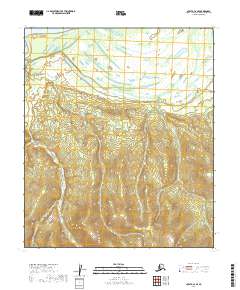
2019 Map of Nulato C-2 SE
USGS Topo · Published 2019About this map
The Yukon River dominates the northern reaches of this landscape, its expansive channel defining the drainage patterns of the western Interior. Below the main river channel, the terrain is shaped by the wandering paths of Kala Slough and Kala Creek, which flow through a complex network of wetlands and low-lying brush. The transition from the alluvial flats of the Yukon valley to the rising upland topography is visible as the terrain climbs toward the south, where Kelly Cr carves through the undulating hills. This 2019 survey provides a clear view of the wilderness hydrology and the Public Land Survey System boundaries, including the intersections of t10s r11e and t11s r11e, which are essential for locating specific land parcels in this remote portion of the Yukon-Koyukuk Census Area.
Find a feature on this map
9 named features on this map. Tap any name to fly to it.
Don’t see what you’re looking for? This feature index may not catch every label — zoom into the map to look around manually.
Map Details
Editions of this 2019 Nulato C-2 SE Map
This is the sole edition of this map. No revisions or reprints were ever made.
Other maps of this area

1945 · Nulato
USGS Topo · 1:250,000

1951 · Nulato
USGS Topo · 1:250,000

1952 · Nulato C-1
USGS Topo · 1:63,360

1952 · Nulato B-2
USGS Topo · 1:63,360

1952 · Nulato B-1
USGS Topo · 1:63,360

1952 · Nulato C-2
USGS Topo · 1:63,360

1952 · Nulato
USGS Topo · 1:250,000
1953 · Nulato C-2
USGS Topo · 1:63,360
1953 · Nulato B-1
USGS Topo · 1:63,360

1964 · Nulato
USGS Topo · 1:250,000