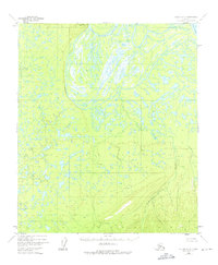
1952 Map of Nulato C-3
USGS Topo · Published 1975About this map
The Yukon River dominates the northeastern corner of this interior Alaska landscape, where it meets the sprawling wetlands of the Pilot Mountain Slough. This region is characterized by a complex network of waterways and low-lying marshlands, notably around the winding course of Bishop Creek. Rising above the surrounding alluvial flats is Pilot Mountain, a significant topographical landmark providing a vertical contrast to the saturated terrain below. The survey reveals a landscape largely defined by natural hydrology, including the drainage of Kinkaid Creek to the east. Compiled from 1952 aerial photography, the map captures a wilderness area in the Kateel River Meridian before significant modern development, showing the intricate patterns of seasonal wetlands and unsurveyed land lines that were predetermined by the Bureau of Land Management.
Find a feature on this map
6 named features on this map. Tap any name to fly to it.
Don’t see what you’re looking for? This feature index may not catch every label — zoom into the map to look around manually.
Map Details
Editions of this 1952 Nulato C-3 Map
4 editions found
Other maps of this area

1945 · Nulato
USGS Topo · 1:250,000

1951 · Nulato
USGS Topo · 1:250,000

1952 · Nulato D-3
USGS Topo · 1:63,360

1952 · Nulato B-2
USGS Topo · 1:63,360

1952 · Nulato C-3
USGS Topo · 1:63,360

1952 · Nulato C-2
USGS Topo · 1:63,360

1952 · Nulato C-4
USGS Topo · 1:63,360

1952 · Nulato D-4
USGS Topo · 1:63,360

1952 · Nulato D-2
USGS Topo · 1:63,360

1952 · Nulato B-3
USGS Topo · 1:63,360