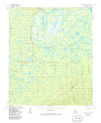
1952 Map of Nulato C-3
USGS Topo · Published 1991About this map
Pilot Mountain Slough and the wide bends of the Yukon River dominate this survey of the Alaskan interior, showing the landscape as it was documented in the early 1950s. The map captures a complex network of waterways and wetlands, anchored by the prominent elevation of Pilot Mountain in the north. Much of the southern and central terrain is preserved within the Inn Oko National Wildlife Refuge, a designation reflecting the area's importance as a wilderness habitat. The drainage patterns of Bishop Creek and Kinkaid Creek illustrate the seasonal flow of water through this subarctic environment, where land lines remain largely unsurveyed and unmarked. This map is a record of a region defined by its lack of roads and permanent settlements, where the river systems provided the primary means of navigation and connection to the broader Yukon valley.
Find a feature on this map
7 named features on this map. Tap any name to fly to it.
Don’t see what you’re looking for? This feature index may not catch every label — zoom into the map to look around manually.
Map Details
Editions of this 1952 Nulato C-3 Map
4 editions found
Other maps of this area

1945 · Nulato
USGS Topo · 1:250,000

1951 · Nulato
USGS Topo · 1:250,000

1952 · Nulato D-3
USGS Topo · 1:63,360

1952 · Nulato B-2
USGS Topo · 1:63,360

1952 · Nulato C-3
USGS Topo · 1:63,360

1952 · Nulato C-2
USGS Topo · 1:63,360

1952 · Nulato C-4
USGS Topo · 1:63,360

1952 · Nulato D-4
USGS Topo · 1:63,360

1952 · Nulato D-2
USGS Topo · 1:63,360

1952 · Nulato B-3
USGS Topo · 1:63,360