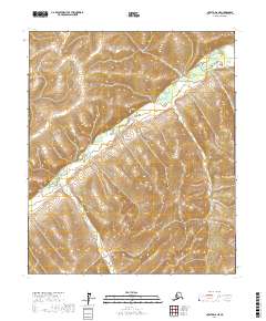
2017 Map of Nulato D-6 NE
USGS Topo · Published 2017About this map
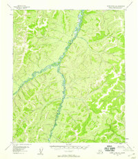
The Gisasa River winds through this interior Alaskan wilderness, following a serpentine path across the western portion of the quadrangle. This 2017 survey captures the natural drainage patterns where the river meanders through a landscape defined by significant elevation changes, as indicated by the tight contour intervals throughout the region. The map reflects the vast, undeveloped character of the Yukon-Koyukuk Census Area, showing no roads, settlements, or established structures. Instead, it provides a precise technical view of the Public Land Survey System divisions, marking the intersections of t6s r1e, t6s r2e, t7s r1e, and t7s r2e. For those studying the geography of the Nulato region, the document offers an exacting look at the hydrological behavior of the river and the surrounding high-country terrain before any human-made infrastructure was introduced to this specific sector.
Find a feature on this map
5 named features on this map. Tap any name to fly to it.
Don’t see what you’re looking for? This feature index may not catch every label — zoom into the map to look around manually.
Map Details
Editions of this 2017 Nulato D-6 NE Map
This is the sole edition of this map. No revisions or reprints were ever made.
Other maps of this area

1945 · Nulato
USGS Topo · 1:250,000

1951 · Nulato
USGS Topo · 1:250,000

1951 · Kateel River
USGS Topo · 1:250,000

1952 · Nulato D-5
USGS Topo · 1:63,360

1952 · Nulato
USGS Topo · 1:250,000
1952 · Kateel River A-5
USGS Topo · 1:63,360
1954 · Kateel River A-5
USGS Topo · 1:63,360
1955 · Nulato D-6
USGS Topo · 1:63,360
1955 · Kateel River A-6
USGS Topo · 1:63,360

1955 · Kateel River
USGS Topo · 1:250,000