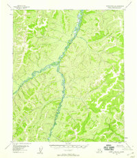
1955 Map of Kateel River A-6
USGS Topo · Published 1958About this map
The Kateel River winds through the Fourth Judicial Division of Alaska, serving as the central topographic feature of this mid-1950s survey. The landscape is defined by a dense network of drainages and high ridges, where the Arveta River flows from the north to join the main channel. To the southeast, the Honhosa River marks the edge of the survey area. This 1955 photogrammetric study, derived from aerial photography, illustrates a completely unpopulated wilderness with no recorded roads or trails at the time of mapping. The intricate contour lines reveal a complex basin where water systems are the primary identifiers in a vast, roadless interior, providing a foundational record of the regional hydrology before later environmental or geographic shifts.
Find a feature on this map
3 named features on this map. Tap any name to fly to it.
Don’t see what you’re looking for? This feature index may not catch every label — zoom into the map to look around manually.
Map Details
Editions of this 1955 Kateel River A-6 Map
2 editions found
Other maps of this area

1945 · Nulato
USGS Topo · 1:250,000

1948 · Norton Bay
USGS Topo · 1:250,000

1951 · Candle
USGS Topo · 1:250,000

1951 · Nulato
USGS Topo · 1:250,000

1951 · Norton Bay
USGS Topo · 1:250,000

1951 · Kateel River
USGS Topo · 1:250,000

1952 · Nulato D-5
USGS Topo · 1:63,360

1952 · Nulato
USGS Topo · 1:250,000
1952 · Kateel River A-5
USGS Topo · 1:63,360

1954 · Candle A-1
USGS Topo · 1:63,360