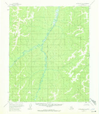
1955 Map of Kateel River A-6
USGS Topo · Published 1972About this map
The Kateel River meanders across this mid-1950s interior landscape, creating a complex network of oxbows and swampy lowlands as interpreted from aerial photography. The terrain is defined by its significant relief, with countless unindexed hills rising sharply from the river valley. This specific survey, based on 1952 and 1955 photography, captures the drainage systems of Arvesta Creek and the Honhosa River in an era when the land lines remained largely unsurveyed and unmarked by the Bureau of Land Management. The lack of named human settlements or infrastructure emphasizes the remote character of this region during the mid-century, where the only established geographic markers are the watercourses that dominate the valley floor.
Find a feature on this map
3 named features on this map. Tap any name to fly to it.
Don’t see what you’re looking for? This feature index may not catch every label — zoom into the map to look around manually.
Map Details
Editions of this 1955 Kateel River A-6 Map
2 editions found
Other maps of this area

1945 · Nulato
USGS Topo · 1:250,000

1948 · Norton Bay
USGS Topo · 1:250,000

1951 · Candle
USGS Topo · 1:250,000

1951 · Nulato
USGS Topo · 1:250,000

1951 · Norton Bay
USGS Topo · 1:250,000

1951 · Kateel River
USGS Topo · 1:250,000

1952 · Nulato D-5
USGS Topo · 1:63,360

1952 · Nulato
USGS Topo · 1:250,000
1952 · Kateel River A-5
USGS Topo · 1:63,360

1954 · Candle A-1
USGS Topo · 1:63,360