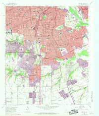
1958 Map of Oak Cliff
USGS Topo · Published 1969About this map
Oak Cliff and south Dallas dominate this mid-century landscape as suburban development pushes into the surrounding creek valleys. The map illustrates a period of significant growth, with purple revision tints marking new residential tracts and industrial sites expanding around Fruitdale and the Trinity River bottomlands. Long-standing local institutions like St Joseph Home for Girls and Sunset High Sch are situated within established neighborhoods, while the southern reaches near Lancaster remain more sparsely settled. Transportation is defined by a dense network of major thoroughfares including Hampton Road and Zangs Boulevard, alongside a complex rail infrastructure featuring the St Louis Southwestern RR and the Missouri Kansas & Texas RR. This survey serves as an essential record for tracing the evolution of family estates into modern additions like Wynnewood, as well as the preservation of large green spaces like Kiest Park and Laurel Land Memorial Park.
Find a feature on this map
105 named features on this map. Tap any name to fly to it.
Don’t see what you’re looking for? This feature index may not catch every label — zoom into the map to look around manually.
Map Details
Editions of this 1958 Oak Cliff Map
5 editions found
Other maps of this area

1891 · Dallas
USGS Topo · 1:125,000

1893 · Dallas
USGS Topo · 1:125,000

1931 · Carrollton
USGS Topo · 1:62,500

1954 · Dallas
USGS Topo · 1:250,000

1957 · White Rock Lake
USGS Topo · 1:24,000

1958 · Dallas
USGS Topo · 1:250,000

1958 · Hutchins
USGS Topo · 1:24,000

1958 · Oak Cliff
USGS Topo · 1:24,000

1958 · Dallas
USGS Topo · 1:24,000

1958 · White Rock Lake
USGS Topo · 1:24,000