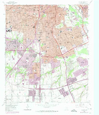
1958 Map of Oak Cliff
USGS Topo · Published 1974About this map
Dallas expansion south of the Trinity River is meticulously documented in this mid-century survey, which details the rapid suburbanization of Oak Cliff and Fruitdale. The landscape is a dense network of civic and religious institutions, including the Veterans Hospital, the St Joseph Home for Girls, and numerous neighborhood schools like Peabody Sch and South Oak Cliff High Sch. Notable for genealogists are the expansive grounds of Laurel Land Memorial Park and the older Lisbon Cem. The area's transit-driven growth is evident in the heavy rail presence of the Missouri Kansas Texas RR and the transition of aviation sites, from the active Red Bird Airport to the Hi Way Airport (Aband). Residential developments like Wynnewood and Woodland Hills contrast with industrial pockets, including Strip Mines near the river bluffs.
Find a feature on this map
88 named features on this map. Tap any name to fly to it.
Don’t see what you’re looking for? This feature index may not catch every label — zoom into the map to look around manually.
Map Details
Editions of this 1958 Oak Cliff Map
5 editions found
Other maps of this area

1891 · Dallas
USGS Topo · 1:125,000

1893 · Dallas
USGS Topo · 1:125,000

1931 · Carrollton
USGS Topo · 1:62,500

1954 · Dallas
USGS Topo · 1:250,000

1957 · White Rock Lake
USGS Topo · 1:24,000

1958 · Dallas
USGS Topo · 1:250,000

1958 · Hutchins
USGS Topo · 1:24,000

1958 · Oak Cliff
USGS Topo · 1:24,000

1958 · Dallas
USGS Topo · 1:24,000

1958 · White Rock Lake
USGS Topo · 1:24,000