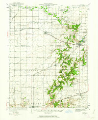
1936 Map of Oakland
USGS Topo · Published 1962About this map
The Embarrass River meanders through the heart of this East Central Illinois landscape, its wooded banks providing a sharp contrast to the dense network of rural schools and family farms in Sargent and Oakland townships. Settlement is anchored by the rail junctions at Hindsboro, Oakland, and Charleston, where the Pennsylvania and Chicago and St Louis railroads intersect the agricultural grid.
Find a feature on this map
94 named features on this map. Tap any name to fly to it.
Don’t see what you’re looking for? This feature index may not catch every label — zoom into the map to look around manually.
Map Details
Editions of this 1936 Oakland Map
5 editions found
Other maps of this area

1933 · Toledo
USGS Topo · 1:62,500

1934 · Mattoon
USGS Topo · 1:62,500

1935 · Arcola
USGS Topo · 1:48,000

1936 · Oakland
USGS Topo · 1:48,000

1936 · Casey
USGS Topo · 1:48,000

1937 · Mattoon
USGS Topo · 1:62,500

1938 · Toledo
USGS Topo · 1:62,500

1940 · Arcola
USGS Topo · 1:62,500

1942 · Oakland
USGS Topo · 1:62,500

1942 · Casey
USGS Topo · 1:62,500