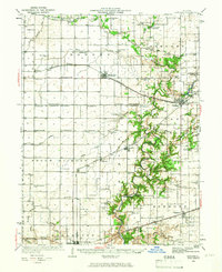
1936 Map of Oakland
USGS Topo · Published 1966About this map
The Embarrass River carves a winding path through this portion of eastern Illinois, providing a stark contrast to the rigid township grid of Coles and Douglas counties. The landscape is a dense network of early 20th-century rural infrastructure, characterized by a one-room schoolhouse in nearly every section, such as Contrary Sch, Egypt Sch, and Martin Box Sch. These small educational outposts, alongside local landmarks like the Brushy Fork Town Hall, reveal the decentralized nature of social life before the consolidation of rural districts.
Find a feature on this map
98 named features on this map. Tap any name to fly to it.
Don’t see what you’re looking for? This feature index may not catch every label — zoom into the map to look around manually.
Map Details
Editions of this 1936 Oakland Map
5 editions found
Other maps of this area

1933 · Toledo
USGS Topo · 1:62,500

1934 · Mattoon
USGS Topo · 1:62,500

1935 · Arcola
USGS Topo · 1:48,000

1936 · Oakland
USGS Topo · 1:48,000

1936 · Casey
USGS Topo · 1:48,000

1937 · Mattoon
USGS Topo · 1:62,500

1938 · Toledo
USGS Topo · 1:62,500

1940 · Arcola
USGS Topo · 1:62,500

1942 · Oakland
USGS Topo · 1:62,500

1942 · Casey
USGS Topo · 1:62,500