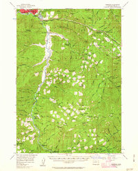
1956 Map of Oakridge
USGS Topo · Published 1963About this map
Oakridge and Willamette City serve as the primary hubs in this mid-century survey, situated at the confluence of several vital mountain waterways. The landscape is defined by the Middle Fork Willamette River and its numerous tributaries, including Salt Creek and Salmon Creek. The Southern Pacific railroad and Southern Pacific Highway parallel these corridors, facilitating movement through the dense terrain of the Willamette National Forest.
Find a feature on this map
122 named features on this map. Tap any name to fly to it.
Don’t see what you’re looking for? This feature index may not catch every label — zoom into the map to look around manually.
Map Details
Editions of this 1956 Oakridge Map
3 editions found

Other maps of this area

1917 · Diamond Lake
USGS Topo · 1:125,000

1925 · Waldo Lake
USGS Topo · 1:125,000

1935 · Lowell
USGS Topo · 1:96,000

1942 · Lowell
USGS Topo · 1:125,000

1955 · Hardesty Mtn
USGS Topo · 1:62,500

1955 · Illahee Rock
USGS Topo · 1:62,500

1955 · Fairview Peak
USGS Topo · 1:62,500

1955 · Chucksney Mtn
USGS Topo · 1:62,500

1956 · Toketee Falls
USGS Topo · 1:62,500

1956 · Waldo Lake
USGS Topo · 1:62,500