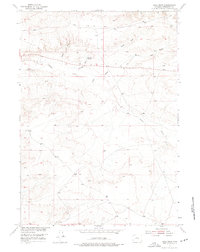
1952 Map of Ocla Draw
USGS Topo · Published 1976About this map
Picard Ranch and the surrounding high plains of Fremont County are captured here as they appeared during a 1952 field survey. The landscape is defined by an intricate network of drainage channels that feed into Poison Creek, illustrating the complex water management required in this arid portion of the Missouri River Basin. The presence of small-scale water storage, including Robinson Reservoir and Ocla Reservoir, points to the vital importance of seasonal runoff for local ranching operations. Significant topographical features like Ocla Draw and North Fork Ocla Draw dominate the terrain, while Scott Draw cuts through the western sections of the map. This study, produced by the Geological Survey as part of a development program for the region, provides a detailed look at the rural infrastructure of central Wyoming during the mid-twentieth century.
Find a feature on this map
8 named features on this map. Tap any name to fly to it.
Don’t see what you’re looking for? This feature index may not catch every label — zoom into the map to look around manually.
Map Details
Editions of this 1952 Ocla Draw Map
2 editions found
Other maps of this area

1951 · Fuller Reservoir
USGS Topo · 1:24,000

1951 · Bonneville
USGS Topo · 1:24,000

1951 · Shoshoni
USGS Topo · 1:24,000

1952 · Squaw Butte NE
USGS Topo · 1:24,000

1952 · Squaw Butte
USGS Topo · 1:24,000

1952 · Ocla Draw
USGS Topo · 1:24,000

1952 · Gates Butte
USGS Topo · 1:24,000

1952 · Picard Ranch
USGS Topo · 1:24,000

1952 · Haybarn Hill
USGS Topo · 1:24,000

1955 · Thermopolis
USGS Topo · 1:250,000