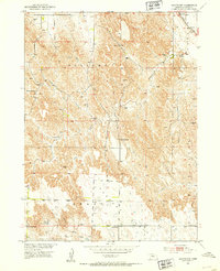
1951 Map of Oconto NW
USGS Topo · Published 1953About this map
Educational outposts like Hillside Sch and Hog Hollow Sch define the rural landscape of Custer County in the early 1950s. This survey, conducted as part of the Department of the Interior program for the development of the Missouri River Basin, reveals a landscape organized into distinct legal townships including Delight, Grant, and Red Fern. The terrain is characterized by a dense network of intermittent drainage feeding into Cottonwood Creek and Spring Creek, punctuated by numerous windmills essential for agricultural life in this region. The Union Pacific railroad corridor cuts across the northeastern corner of the map, providing a vital link for the scattered farmsteads and schools such as Cottonwood Sch and Redfern Sch. The presence of Happy Hollow Sch in the southwest further illustrates the distributed nature of community infrastructure before the consolidation of rural school districts.
Find a feature on this map
14 named features on this map. Tap any name to fly to it.
Don’t see what you’re looking for? This feature index may not catch every label — zoom into the map to look around manually.
Map Details
Editions of this 1951 Oconto NW Map
3 editions found
Other maps of this area

1951 · Callaway SE
USGS Topo · 1:24,000

1951 · Callaway
USGS Topo · 1:24,000

1951 · Oconto SW
USGS Topo · 1:24,000

1951 · Oconto SE
USGS Topo · 1:24,000

1951 · Oconto NW
USGS Topo · 1:24,000

1951 · Oconto
USGS Topo · 1:24,000

1954 · North Platte
USGS Topo · 1:250,000

1955 · Broken Bow
USGS Topo · 1:250,000

1956 · Broken Bow
USGS Topo · 1:250,000

1956 · North Platte
USGS Topo · 1:250,000