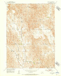
1951 Map of Oconto SE
USGS Topo · Published 1953About this map
Wood River and its intricate network of drainage, including Buffalo Creek and East Buffalo Creek, define this rural Nebraska landscape along the borders of Custer, Dawson, and Buffalo Counties. In the early 1950s, the area remained a tapestry of small rural school districts and community centers. Educational hubs such as Montrose Sch, Lone Eagle Sch, and Pleasant Hill Sch are found alongside religious centers like the Lutheran Ch.
Find a feature on this map
14 named features on this map. Tap any name to fly to it.
Don’t see what you’re looking for? This feature index may not catch every label — zoom into the map to look around manually.
Map Details
Editions of this 1951 Oconto SE Map
3 editions found
Other maps of this area

1896 · Lexington
USGS Topo · 1:125,000

1899 · Lexington
USGS Topo · 1:125,000

1951 · Oconto SW
USGS Topo · 1:24,000

1951 · Eddyville NW
USGS Topo · 1:24,000

1951 · Oconto SE
USGS Topo · 1:24,000

1951 · Eddyville SW
USGS Topo · 1:24,000

1951 · Oconto NW
USGS Topo · 1:24,000

1951 · Oconto
USGS Topo · 1:24,000

1955 · Broken Bow
USGS Topo · 1:250,000

1955 · Grand Island
USGS Topo · 1:250,000