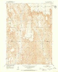
1951 Map of Oconto SW
USGS Topo · Published 1953About this map
Red Fern Table and the surrounding high plains of central Nebraska define this mid-century landscape on the border of Custer and Dawson Counties. The survey reflects a sparsely populated agrarian region where social and community life centered on localized rural institutions. Small schoolhouses like Sunny Hill Sch, School No 11, and School No 54 dot the section lines, alongside the Pleasant Valley Ch and the Lemmery Sch to the south. The drainage patterns of Spring Creek, West Buffalo Creek, and East Buffalo Creek carve through the townships of Grant and Gillan, illustrating the vital water resources that supported the area's cattle ranching and farming operations during the early 1950s development of the Missouri River Basin.
Find a feature on this map
13 named features on this map. Tap any name to fly to it.
Don’t see what you’re looking for? This feature index may not catch every label — zoom into the map to look around manually.
Map Details
Editions of this 1951 Oconto SW Map
3 editions found
Other maps of this area

1896 · Lexington
USGS Topo · 1:125,000

1899 · Lexington
USGS Topo · 1:125,000

1902 · Gothenburg
USGS Topo · 1:125,000

1951 · Oconto SW
USGS Topo · 1:24,000

1951 · Oconto SE
USGS Topo · 1:24,000

1951 · Oconto NW
USGS Topo · 1:24,000

1951 · Oconto
USGS Topo · 1:24,000

1954 · McCook
USGS Topo · 1:250,000

1954 · North Platte
USGS Topo · 1:250,000

1955 · Broken Bow
USGS Topo · 1:250,000