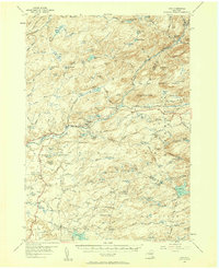
1954 Map of Ohio
USGS Topo · Published 1957About this map
The Adirondack Park boundary cuts through this mid-century survey of Herkimer and Hamilton counties, revealing a landscape defined by the drainage of West Canada Creek and the Black River. High-elevation wetlands known locally as "vlys"—such as Whiskey Spring Vly and Crosby Vly—pepper the terrain between peaks like Fort Noble Mtn and McCauley Mtn. This era shows a network of isolated rural settlements and crossroads including Nobleboro, Morehouseville, and Wilmurt Corners. Cultural markers of the early 20th century are still prominent, from the War Memorial Monument to local schools like Wilmurt Sch and Reising Sch. Genealogists will find several family-named burial grounds, including the McIntosh Cem and Brondstatter Cem, while the inclusion of the Lookout Tower on Fort Noble Mountain highlights the period's active fire observation infrastructure.
Find a feature on this map
133 named features on this map. Tap any name to fly to it.
Don’t see what you’re looking for? This feature index may not catch every label — zoom into the map to look around manually.
Map Details
Editions of this 1954 Ohio Map
4 editions found
Other maps of this area

1897 · Remsen
USGS Topo · 1:62,500

1898 · Utica
USGS Topo · 1:62,500

1900 · Little Falls
USGS Topo · 1:62,500

1900 · Utica
USGS Topo · 1:62,500

1900 · Remsen
USGS Topo · 1:62,500

1900 · Canada Lake
USGS Topo · 1:62,500

1900 · Wilmurt
USGS Topo · 1:62,500

1901 · Old Forge
USGS Topo · 1:62,500

1901 · Lassellsville
USGS Topo · 1:62,500

1902 · Wilmurt
USGS Topo · 1:62,500