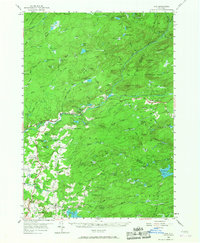
1954 Map of Ohio
USGS Topo · Published 1967About this map
Adirondack Park dominates the landscape of this mid-century survey, revealing a region defined by extensive wetlands, small settlements, and the rugged drainage of the Black River. The settlement of Nobleboro sits at a geographic crossroads near the Ohio Gorge, while further east, Morehouseville serves as a remote hub along the primary thoroughfare. The map detail reflects the social infrastructure of the era, pinpointing localized landmarks such as the Reising Sch, Wilmurt Sch, and Turner Sch.
Find a feature on this map
99 named features on this map. Tap any name to fly to it.
Don’t see what you’re looking for? This feature index may not catch every label — zoom into the map to look around manually.
Map Details
Editions of this 1954 Ohio Map
4 editions found
Other maps of this area

1897 · Remsen
USGS Topo · 1:62,500

1898 · Utica
USGS Topo · 1:62,500

1900 · Little Falls
USGS Topo · 1:62,500

1900 · Utica
USGS Topo · 1:62,500

1900 · Remsen
USGS Topo · 1:62,500

1900 · Canada Lake
USGS Topo · 1:62,500

1900 · Wilmurt
USGS Topo · 1:62,500

1901 · Old Forge
USGS Topo · 1:62,500

1901 · Lassellsville
USGS Topo · 1:62,500

1902 · Wilmurt
USGS Topo · 1:62,500