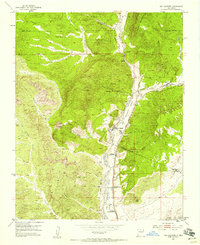
1953 Map of Ojo Caliente
USGS Topo · Published 1957About this map
Ojo Caliente serves as the focal point of this mid-century New Mexico landscape, situated along the banks of the Rio Ojo Caliente. The map reveals a string of settlements and post offices through the river valley, including Gallegos, Duranes, and Gavilan, providing a clear record of local habitation patterns prior to later development. The terrain is defined by the La Madera Mountains to the east and the prominent Cerro Colorado to the west, with the Carson National Forest boundary marking the northern reach of the survey. Mineral interests are evident through the presence of the San Texas Mine and Joseph Mine tucked into the arroyos. Historical researchers will find value in the identification of the Ojo Caliente Grant Boundary and the locations of local landmarks such as the Ojo Caliente School and multiple community cemeteries.
Find a feature on this map
47 named features on this map. Tap any name to fly to it.
Don’t see what you’re looking for? This feature index may not catch every label — zoom into the map to look around manually.
Map Details
Editions of this 1953 Ojo Caliente Map
Other maps of this area

1918 · Abiquiu
USGS Topo · 1:125,000

1953 · Medanales
USGS Topo · 1:24,000

1953 · Valle Grande Peak
USGS Topo · 1:24,000

1953 · Lyden
USGS Topo · 1:24,000

1953 · Velarde
USGS Topo · 1:24,000

1953 · El Rito
USGS Topo · 1:24,000

1953 · La Madera
USGS Topo · 1:24,000

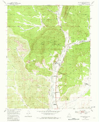
1953 · Ojo Caliente
USGS Topo · 1:24,000

1953 · San Juan Pueblo
USGS Topo · 1:62,500

1954 · Raton
USGS Topo · 1:250,000