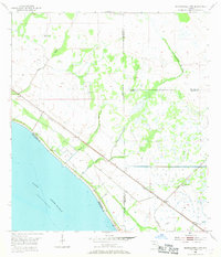
1953 Map of Okeechobee 4 NW
USGS Topo · Published 1969About this map
Lake Okeechobee dominates the southwestern corner of this survey, bordered by a complex network of levees and spoil banks. The landscape is defined by the intersection of water and rail, with the Seaboard Air Line and the F E C railroad corridors cutting through the low-lying terrain. The northeastern shore of the lake is fed by several water bodies, including Henry Creek, Lettuce Creek, and Nubbin Slough, illustrating the natural drainage patterns of the region before further modern developments. Small railroad-aligned settlements like Marcy and Myrtle appear as remote outposts in a territory marked by numerous flowing wells and windmills. This map captures the meeting point of four Florida counties, showing the intricate boundaries between Okeechobee, Palm Beach, St. Lucie, and Martin counties as they converge near the lake's edge.
Find a feature on this map
16 named features on this map. Tap any name to fly to it.
Don’t see what you’re looking for? This feature index may not catch every label — zoom into the map to look around manually.
Map Details
Editions of this 1953 Okeechobee 4 NW Map
4 editions found
Other maps of this area

1952 · Okeechobee
USGS Topo · 1:24,000

1953 · Okeechobee 4 SW
USGS Topo · 1:24,000

1953 · Okeechobee 4 SE
USGS Topo · 1:24,000

1953 · Okeechobee 1 SE
USGS Topo · 1:24,000

1953 · Okeechobee 4 NE
USGS Topo · 1:24,000

1953 · Okeechobee 4 NW
USGS Topo · 1:24,000

1953 · Okeechobee 1 SW
USGS Topo · 1:24,000

1953 · Taylor Creek SE
USGS Topo · 1:24,000

1956 · Fort Pierce
USGS Topo · 1:250,000

1958 · Fort Pierce
USGS Topo · 1:250,000