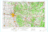
1957 Map of Oklahoma City
USGS Topo · Published 1974About this map
Oklahoma City and its surrounding counties are documented during a period of significant mid-century expansion and infrastructure development. The central urban landscape is dominated by the State Capitol and major educational institutions such as Oklahoma City University and the University of Oklahoma to the south in Norman. This 1:250,000 scale view reveals the sophisticated transportation network of the era, from the path of the Turner Turnpike leading northeast toward Sapulpa and Tulsa to the dense rail corridors of the Atchison Topeka and Santa Fe Ry and the St Louis-San Francisco Ry.
Find a feature on this map
93 named features on this map. Tap any name to fly to it.
Don’t see what you’re looking for? This feature index may not catch every label — zoom into the map to look around manually.
Map Details
Editions of this 1957 Oklahoma City Map
3 editions found

Other maps of this area

1892 · Moore
USGS Topo · 1:62,500

1892 · Guthrie
USGS Topo · 1:62,500

1892 · Edmond
USGS Topo · 1:62,500

1892 · Kingfisher
USGS Topo · 1:125,000

1893 · Norman
USGS Topo · 1:62,500

1893 · Fort Reno
USGS Topo · 1:62,500

1893 · Mulhall
USGS Topo · 1:62,500

1893 · Oklahoma City
USGS Topo · 1:62,500

1893 · Lovell
USGS Topo · 1:62,500

1893 · Buggy Creek
USGS Topo · 1:62,500