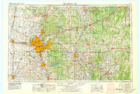
1957 Map of Oklahoma City
USGS Topo · Published 1979About this map
The Oklahoma City metropolitan area and its surrounding oil-producing counties are shown at a pivotal moment of post-war growth and infrastructure development. The city's northward expansion is marked by affluent enclaves like Nichols Hills and The Village, while the strategic importance of Tinker Air Force Base anchors the development to the east. Transportation corridors define the region's connectivity, specifically the diagonal path of the Turner Turnpike stretching toward Tulsa. Outside the urban center, the landscape is dictated by the courses of the Cimarron River and North Canadian River. Further south, the map illustrates the academic and cultural hub around the University of Oklahoma in Norman. This survey provides a record of the region's hydraulic engineering, capturing reservoirs such as Lake Hefner and Lake Thunderbird that supported the burgeoning population.
Find a feature on this map
98 named features on this map. Tap any name to fly to it.
Don’t see what you’re looking for? This feature index may not catch every label — zoom into the map to look around manually.
Map Details
Editions of this 1957 Oklahoma City Map
3 editions found

Other maps of this area

1892 · Moore
USGS Topo · 1:62,500

1892 · Guthrie
USGS Topo · 1:62,500

1892 · Edmond
USGS Topo · 1:62,500

1892 · Kingfisher
USGS Topo · 1:125,000

1893 · Norman
USGS Topo · 1:62,500

1893 · Fort Reno
USGS Topo · 1:62,500

1893 · Mulhall
USGS Topo · 1:62,500

1893 · Oklahoma City
USGS Topo · 1:62,500

1893 · Lovell
USGS Topo · 1:62,500

1893 · Buggy Creek
USGS Topo · 1:62,500