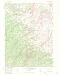
1955 Map of Old Roach
USGS Topo · Published 1970About this map
High-altitude ranching and the complex water management of the Laramie River basin define this mid-century survey along the Colorado-Wyoming border. The landscape is dominated by the Medicine Bow National Forest, where a network of drainages like Stuck Creek and Fish Creek feed numerous Beaver Ponds tucked into the timbered slopes. Evidence of earlier settlement is found at Old Roach (Aband), while the operational Grace Creek Ranch reflects the era's ongoing agricultural presence. A sophisticated system of irrigation works, including the Boswell Ditch, Slough Creek Ditch, and the Johnson Reservoir (Hohnsholt Lake) with its noted Spillway 7904, illustrates how water was diverted from the Laramie River to support the high plains. Between the peaks of Pollock Knob and Mansfield Hill, the map traces the intricate headwaters of the South Fork and Forrester Creek as they descend toward the river valley.
Find a feature on this map
33 named features on this map. Tap any name to fly to it.
Don’t see what you’re looking for? This feature index may not catch every label — zoom into the map to look around manually.
Map Details
Editions of this 1955 Old Roach Map
5 editions found

Other maps of this area

1895 · Laramie
USGS Topo · 1:125,000

1902 · Laramie
USGS Topo · 1:125,000

1905 · Laramie
USGS Topo · 1:125,000

1906 · Medicine Bow
USGS Topo · 1:125,000

1906 · Laramie
USGS Topo · 1:125,000

1908 · Laramie
USGS Topo · 1:125,000

1908 · Medicine Bow
USGS Topo · 1:125,000

1916 · Home
USGS Topo · 1:125,000

1920 · Home
USGS Topo · 1:125,000

1950 · Kings Canyon
USGS Topo · 1:24,000